NYMTC collects and analyzes data which are used in publications and reports that focus on improving the region’s transportation infrastructure and identifying the future needs of the New York metropolitan area.
Efficient and effective transportation systems improve mobility and help communities flourish. They support regional economic development and preserve the quality of life in neighborhoods. Planning for transportation infrastructure requires the ability to forecast travel demand on the transportation system through models that consider the complex movement of individuals and goods in order to meet the changing needs of the traveling public. Released in 2015, NYMTC currently employs a 2012 Base Year for the NYBPM.
NYMTC's NYBPM predicts changes in future travel patterns in response to changes in the demographic profiles and transportation systems in the region. It incorporates transportation behavior and relationships with an extensive set of data that includes a major travel survey of households in the region, land-use inventories, socioeconomic data, traffic and transit counts, and travel times.

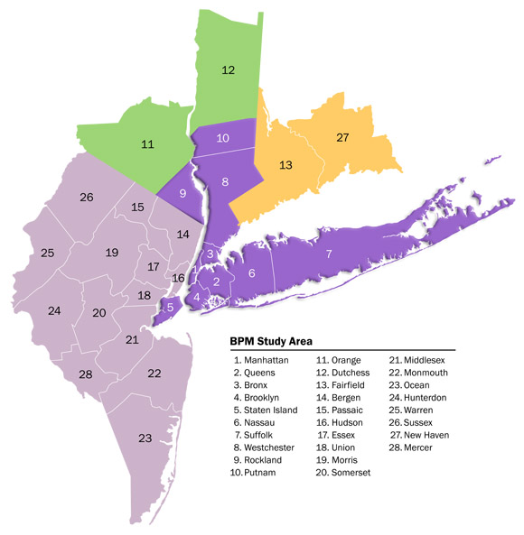
The model includes 28 counties in New York, New Jersey, and Connecticut. All road types from minor arterials and above are represented in the highway network. The transit route system includes all forms of public transportation at the individual route level in the transit network database.
NYBPM Applications
The NYBPM is a powerful tool used to perform the federally-required Transportation Conformity Determination and Regional Emissions Analysis, and to assess projects in the
Regional Transportation Plan (the Plan) and Transportation Improvement Program (TIP). It provides measures for the Congestion Management Process (CMP) and facilitates Major Investment Studies (MIS). The model outputs are used for local studies (sub-regional, corridor analysis, and project level) in the region, and by researchers all over the world.